The heart of Egyptian capital Cairo is currently subjected to systematic theft, where international organizations and foreign circles are involved, in complicity with personalities and centers of influence within the Egyptian government, to control the entire area extending from Mokattam Mountain to the Nile River and internationalize it with the aim of creating a closed city to be inhabited and managed by foreigners, similarly to the Green Zone in Baghdad.
The theft is carried out under the guise of preserving Historic Cairo, and restoring the heart of the capital in the nineteenth century, as shown in the map identified by some French campaign scholars in the book “Description of Egypt” in 1807, the map drawn by the Frenchman L. Thuillier in 1888, and the map drawn by Grand Bey, director of organization in Cairo in 1974.
This movement is carried out under the guise of granting the whole area to the UNESCO as a world heritage area, and consequently internationalizing its administration and removing the State’s authority off the whole area, including the archaeological sites and modern areas that have been annexed as a buffer zone, under the supervision of international experts.
In coincidence with the allegation to transform the heart of Cairo into a museum and historical heritage for tourists, they are implementing the Cairo 2050 plan adopted by the United Nations Human Settlements Program that pursues changing the demography of the area through eviction of Egyptian population and building towers and skyscrapers overlooking the Nile to accommodate foreigners working in Egypt instead.
Borders of Islamic Cairo
The story starts with a proposal submitted by the Ministry of Culture to UNESCO to annex Islamic Cairo to the world heritage to secure spending and restoration of the area, initially including the following Islamic archaeological sites (from south to north):
1- Al-Fustat, the first capital of Egypt under Muslim rule, including the Amr Ibn Al-Aas Mosque (founded in 641), the Roman Wax Castle Palace, the Babylon Fortress with its Coptic churches, and the ruins and excavations of the Fustat City.
2- The Ahmad Ibn Tulun Mosque (founded in 876) and the outskirts of al-Saliba and al-Kabsh areas, containing a number of major Mamluk monuments.
3- The Citadel (al-Qalaa) area and the surrounding Mamluk palaces, the Sultan Hassan Mosque (1356-1359), and the Darb al-Ahmar area, including its historic streets such as Suq al-Silah and Kat al-Tabbaneh, surrounded by Mamluk and Ottoman monuments.
4- Fatimid Cairo, from Bab Zuweila to the northern wall, containing the city gates: Bab al-Futuh and Bab al-Nasr; and the area includes many Ayyubid and Mamluk monuments on the main city avenue (the Great Street).
5- Cemeteries, extending from Fustat to the northern outskirts of Fatimid Cairo, including a large number of mausoleums and tombs from different historical periods.
The pressure practiced by Western circles to convert Cairo into a heritage area have started early. In 1997, the United Nations Development Program (UNDP) started taking care of the file and issued a report in cooperation with the Supreme Council of Antiquities about the rehabilitation of Historic Cairo, proposing an action plan and strategy for rehabilitation that consisted of five urban areas: a heritage corridor, an institutional corridor, Nineteenth century corridor, transformation zone, and communal zone. Urban policies have been proposed including feasible implementation of rehabilitation strategies.
The Egyptian proposals regarding the boundaries of the area to be annexed to the World Heritage were subject to controversy and discussions with the international envoys of UNESCO and the United Nations, until 2006 when the Ministry of Culture presented its vision of Historic Cairo and its boundaries, at the request of the United Nations Development Program and UNESCO, as follows:
– The northern border: the northern Ayyubid wall and its two gates.
– The southern border: Bab Zuweila and Ahmed Maher Street.
– The eastern border: Salah Salem Street.
– The western border: Port Said Street.
The Ministry of Culture’s proposal was not accepted, because it did not reach the limits seen by UNESCO experts. In October 2007, the Supreme Council of Antiquities presented a new vision for the demarcation of Historic Cairo, showing five basic areas and 3 buffer zones for protection. The five basic areas were:
1- Al-Fustat region, including the Amr Ibn Al-Aas Mosque, the Coptic complex, and excavations.
2- The Fatimid nucleus, the Citadel area, and the area surrounding the Ahmed Ibn Tulun Mosque.
3- The Imam al-Shafi’i cemeteries
4- The Al-Sayeda Nafeesah cemeteries
5- The Qaitbay cemeteries
The Supreme Council of Antiquities’ perception did not include the Bulaq Port, nor did it include modern areas, which was not approved by UNESCO, which insisted on annexing the entire area from the Mokattam Mountain to the Nile River shore.
Here, came the role of the National Organization for Urban Harmony (NOUH), which has the authority to demarcate and define “areas of distinct value”, according to Law No. 119 of 2008. NOUH then decided to define the regions of Historic Cairo, Khedive Cairo and Garden City as “areas of distinct value”, and expanded inclusion of real estate on the list of distinguished buildings in the area extending from Mokattam Mountain to the Nile River, to include the pre-modern city and the modern city.
The perception of the area boundaries submitted by the National Organization for Urban Harmony matched with the UNESCO proposal, which was called “The World Heritage Property of Historic Cairo”; and the northern part of Zamalek Island was annexed to it.
The European enthusiasm increased, especially France, and the rush in the plan to seize the heart of Cairo appeared in 2009 when former President Hosni Mubarak was thinking about passing power to his oldest son. At that time, they considered it an opportunity to pass the scheme to control Cairo through Gamal Mubarak through exploitation of his need for international support. After several demands and urgings by the World Heritage Committee, the Egyptian government agreed with UNESCO to prepare joint activities aimed at protecting and reviving the urban heritage of Historic Cairo within the framework of UNESCO’s program titled, “Protection of Cultural Heritage in Egypt”. Then, the UNESCO’s “Urban Regeneration for Historic Cairo (URHS)” project started operation in 2010.
The URHS Project
The UNESCO’s World Heritage Program launched the Urban Regeneration for Historic Cairo (URHS) project in July 2010, after obtaining approval from the Egyptian government of the detailed proposal for technical support, funded by a UNESCO special account, dedicated to protection of the cultural heritage of Egypt.
However, the work of committees was temporarily halted due to the January revolution (2011), and the project span was extended to 42 months, until December 2013, where the project did not stop despite the political conflict and instability during that period due to cooperation with senior personnel in various ministries and official bodies, associated with international bodies (a large number of them may not realize the political goals hidden behind the flashy designs and slogans).
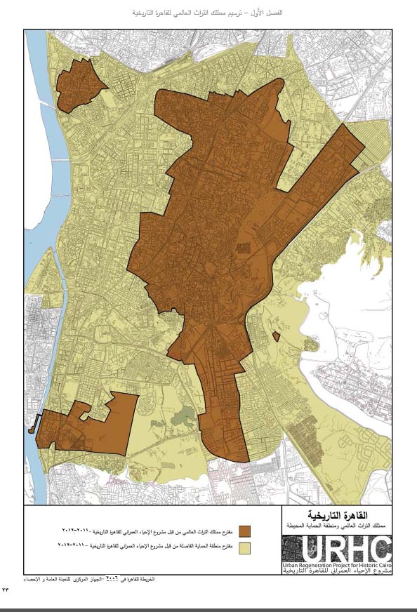
While the Egyptians were busy in drafting the 2012 Constitution and presidential elections, the UNESCO issued its first report on the “Urban Regeneration for Historic Cairo” project in June 2012, stating that the boundaries of the Cairo human heritage property start from the Citadel (al-Qalaa) and Mokattam Mountain in the east to the east bank of the River Nile in the west, and from Ramses and the ancient Bulaq Port in the north to Fustat in the south. The report included a map showing the archaeological areas in brown and the rest of modern Cairo in yellow, where it was called the “Separation Protection Zone”. See the map below:
In 2014, UNESCO issued its second report on its activity during the period from July 2012 to November 2014, confirming the boundaries of the “World Heritage property of Cairo” and published more maps, as well as its proposals to stop construction, investment of vacant lots and the lands that will be evacuated. The UNESCO also presented its vision of the required policies, the laws to be enacted, and the nature of the administration needed to accelerate implementation.

After the UNESCO report was issued, Abdel Fattah El-Sisi, who was in need of international support after the coup d’état that he had led against the first democratically elected President Mohamed Morsi, decided to appoint Prime Minister Ibrahim Mehleb as head of the ministerial committee that would implement the necessary measures for the URHC Project, where he (Mehleb) issued the Prime Minister Decree No. 1420 of 2014. The committee is composed of the ministers of tourism, planning, local development, urban development and Wakfs – which owns most of the real estate in Islamic Cairo – housing, culture, international cooperation, environment, antiquities, the governor of Cairo, and a representative of the General Administration of Cairo Traffic to be nominated by the Minister of Interior.
A Trick under the Guise of Historic Cairo
The most important recommendation in the UNESCO report was to define a priority strategic work area, and implement a conservation plan for that area, which can be later applied to the entire site. It was logical for the strategic work area to be the Citadel and Islamic Cairo, but what happened was that the strategic work area where execution started was the eastern bank of the Nile River, most prominently the Tahrir Square; therefore, the Maspero Triangle was evacuated from Egyptians and evacuation of government personnel from Khedive Cairo has started, and private companies started to buy buildings down town and evicts their population with European funding.
It is not logical in the midst of the talk about restoration of Historic Cairo in the nineteenth century to turn its western side, overlooking the Nile, into skyscrapers crowded with foreigners instead of the indigenous population. Therefore, another international body appeared for providing the required cover for implementation of the demographic and urban change plan, that is the UN Human Settlements Program that supports the Cairo 2050 plan, which was passed by the Urban Planning Authority and adopted by Gamal Mubarak, son of late President Mubarak before the revolution.
The Cairo 2050 plan that was passed by the Urban Planning Authority (when the current Prime Minister Dr. Mostafa Madbouly was its chairman) is the original plan that is currently implemented. The plan focuses on disposal of residents and expelling them from Cairo’s central area, and closure of markets and commercial areas such as Ataba, Tawfiqeya and Abdel Aziz St., Al-Azhar and others; where the expelled residents go to Al-Shorouk, Al-Obour and Badr in northeastern Cairo, and the 6th of October City, west of the Nile, with the evicted lots to be handed over to investors for building hotels and towers to accommodate more foreigners as a future international administration area.
The striking remark in the Cairo 2050 plan is the focus not only on emptying the area from Mokattam to the Nile, but the maps also revealed expansion to the west of the Nile to create a backyard across the north of Zamalek Island and Warraq Island – which the government is attempting to expel its residents, bringing the “vacuum” area to Sphinx Square in Mohandessin, where the so-called “Khufu Avenue”, extending for a distance of 12 km with a width of 600 meters, begins, through the Arab League St. up to the Pyramids; that is, demolition of homes and removal of residents from about half of the Giza Governorate (See my article published by the Egyptian Institute for Studies, titled: “Systematic Policies: Eviction and Displacement of Egyptians!”).
The most important goal of the Cairo 2050 plan is to build a modern settlement and urban area east of the Nile, which has nothing to do with Historical Cairo that is used to justify the eviction and sale of State assets, where multi-storey building activities have not stopped despite suspension of construction in Cairo and all other governorates, and in spite of the wave of demolition of the more-than-4/5-storey buildings under the guise of violation of the Building Code!
The Western minds standing behind the control over the heart of Cairo are the ones that select the Gulf companies, especially the UAE companies to undertake construction in the strategic area and building of towers there, where the government has no role but to expel the population, dismantle facilities and sell assets via the so-called ‘Sovereign Fund’, so that Egyptian authorities will not have any presence in the new project area (Egyptian government owns only 10% of the Maspero Triangle land, while Gulf companies possess 65%).
What after?
We are facing an international crime to steal the heart of Cairo, in a cunning attempt to hijack the capital of the largest Arab country with twisted plans that appear to protect the heritage, but in reality they target stealing the land, eviction of the population to be replaced with non-Egyptians, dismantling the government-owned assets and expelling it to the desert, and evacuation of markets that represent the backbone of economy in Egypt. All these acts are done to allow establishment of a settlement to be governed and managed by the new population of investors and businessmen who have bought most of companies’ shares on the stock exchange, and to whom the ownership of State assets offered for sale will be transferred.
To Read Text in PDF Format Click here.